
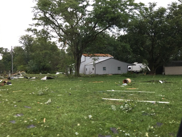
August 24, 2016 storm damage near the intersection of State Road 101 And Notestine Road in northeastern Allen County, Indiana. W9SAN photo.
A tornado outbreak occurred in Indiana and Ohio August 24, 2016. Storms did considerable damage in several of the 11 counties covered by the IMO SKYWARN quadrant two net on the Allen County Amateur Radio Technical Society 146.88 MHz repeater in Fort Wayne. Below is a log of the net’s operations that day.
All Times EDT
1510 Began standby mode operation on IMO SKYWARN quadrant two ham radio frequency.
1713 K9RFZ reports 6 inches of standing water in Fort Wayne on Washington Center Road, east of N. Clinton St.
1714 Invoked directed net due to tornado warning in northeastern Allen County, Indiana (During a directed net, all stations remain off the air unless they have severe weather to report.)
1723 W9SAN confirms wall cloud, I-469 at State Road 37.
1729 KC9CGN confirms tornado, near intersection of Doty Rd. and Ricker Rd.
1736 KA9IPA confirms tornado north of Woodburn.
1740 KA9IPA reports several buildings down at Doehrman Rd. and Roemke Rd.
1755 KB9WWM reports damage at Notestine Rd. and State Road 101: Several buildings damaged, small limbs down, one tree “decapitated.”
1756 WD8JVV relays trained amateur radio spotter report of tornado on ground near intersection of Defiance County Roads 220 & 53.
1801 WD8JVV, Defiance County liaison, reports going off air to take shelter.
1811 KB9NKM reports possible tornado IN SR 101 at IN SR 124. Tree line obscuring his view of ground.
1813 KB9NKM confirms funnel cloud, not touching ground at this time.
1813 KC9MUT confirms funnel cloud near State Road 101 and State Road 124
1830 WD8JVV relays report of confirmed tornado on ground, damage unknown, Brunersburg, OH, near Defiance.
1833 KB9NKM reports tornado on the ground approximately 3 miles NE of Wren, Ohio.
1841 WD8JVV relays report of damage north of Defiance, Flory Rd. at Rd 66, multiple mobile homes destroyed. Casualties unknown.
1848 KB9NKM reports dual vortex funnel clouds approximately three miles northwest of Van Wert.
1940 KB9WWM reports possible wall cloud approximately three miles west of Yoder. Unable to confirm rotation.
2000 Directed net discontinued due to expiry of Allen County tornado warning. Standby mode implemented. Stations who stood by but did not transmit due to having no severe weather to report invited to check in:
- AC9ME
- K9JDF
- KB9AYS
- KB9BNI
- KB9CYG
- KB9DOS
- KB9DOT
- KB9DOY
- KB9WNY
- KC9APP
- KC9CGG
- KC9EZP
- KC9MOE
- KC9PVE
- KC9PWM
- KC9YBM
- KC9ZZM
- KD1MTI
- KD9CYG
- KD9EOF
- KD9GDY
- KD9GDZ
- KD9GDZ
- KF9HA
- KF9YP
- N9JFS
- N9JTB
- N9RIS
- N9VAJ
- N9WLW
- W9LAN
- WB9AA
- WB9NOO
Stations who submitted reports during the operation included:
- KA9IPA
- KB9WWM
- KC9CGN
- KB9NKM
- KC9MUT
- K9RFZ
- W9SAN
Total number of stations participating, including net control station W9LW: 41.